Africa is the hottest continent of the Earth. In addition to its extreme heat, Africa is noted for its ferocious animals and vast desert.
In the midst of Africa is the hot, dry Sahara Desert, which has storms of scorching sand raised by the wind. The Sahara Desert is around 3,000 miles (4,828 km) long and 1,000 miles (1,609 km) wide. It contains vast, sandy plains which are dry, hot, and barren, except in some green places, called oases.
In historical times, people once crossed the desert in large companies, called caravans, in order to defend themselves from robbers.
Exotic animals such as the elephant, lion, camel, leopard, hyena, and zebra are found in Africa. Crocodiles and snakes are dangerous reptiles that live in Africa. Trees include the coconut, date, and palm. Palm trees produce palm oil, which is used in making soap and candles.
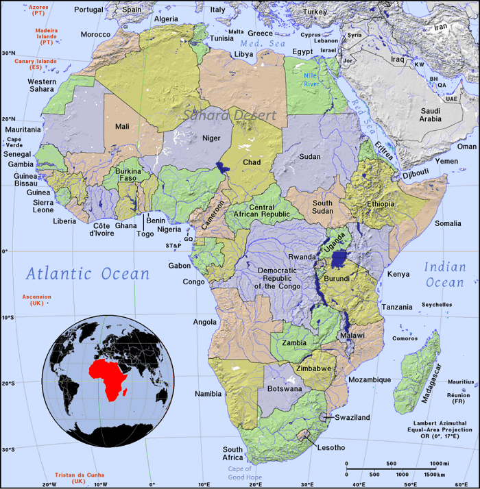
QUESTIONS - Examine the map and answer the questions. Continent of Africa
Between which two oceans is Africa?
Which continent is north of Africa?
Which sea is directly north of Africa?
Which sea is directly northeast of Africa?
Which large island is southeast of Africa?
Which cape is in the southern part of Africa?
Which large Africa flows through Egypt into the Mediterranean Sea?
What desert is in the north of Africa?
Which three countries border the western side of Sudan?
With what ocean is the Red Sea connected to the south?
Which four African countries border the Red Sea?
Which African country is the farthest south?
Which African countries border the Mediterranean Sea?
Which small, roughly circular countries border South Africa?
Which large island is off the coast of Mozambique?
Which country comes to a point in the Indian Ocean?
Which coastal country is between Ghana and Benin?
Which African countries are landlocked?
ANSWERS
The Atlantic Ocean and the Indian Ocean are two oceans is Africa.
Europe is the continent north of Africa.
The Mediterranean Sea is the sea north of Africa.
The Red Sea is the sea northeast of Africa.
Madagascar is the large island southeast of Africa.
The Cape of Good Hope is in the southern part of Africa.
The Nile River is the large African river flowing through Egypt into the Mediterranean Sea.
The Sahara Desert is the desert in the north of Africa.
Libya, Chad, and the Central African Republic border the western side of Sudan.
The Red Sea is connected to the south with the Indian Ocean.
Egypt, Sudan, Eritrea, and Djibouti are four African countries bordering the Red Sea.
South Africa is the farthest south of the African countries.
Morocco, Algeria, Tunisia, Libya, and Egypt are African bordering the Mediterranean Sea.
Lesotho and Swaziland are small, roughly circular countries bordering South Africa.
Madagascar is a large island off the coast of Mozambique.
Somalia comes to a point in the Indian Ocean.
Togo is a coastal country between Ghana and Benin.
Mali, Burkina Faso, Niger, Chad, Central African Republic, South Sudan, Ethiopia, Uganda, Rwanda, Burundi, Malawi, Zambia, Botswana, Zimbabwe, Lesotho, and Swaziland are landlocked African countries.
Notebook Work: Label the following on the map of Africa: The Atlantic Ocean, the Indian Ocean, the Mediterranean Sea, the Sahara Desert, the Cape of Good Hope, the Nile River (draw the river), Libya, Chad, Egypt, Sudan, South Africa, Madagascar, Morocco, Algeria, and Somalia.
 First Lessons in World Geography
World Geography
First Lessons in World Geography
World Geography


 About
About Curriculum
 Navigation